Geolocate

Orile topographic map

Click on the map to display elevation.

About this map

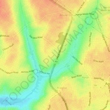
Name: Orile topographic map, elevation, terrain.

Location: Orile, Alimosho, Lagos State, Nigeria (6.61333 3.28000 6.65333 3.32000)

Average elevation: 125 ft

Minimum elevation: 36 ft

Maximum elevation: 184 ft

Gear up for your next adventure:

🌲Outdoor Survival Books - Best books on survival skills
🧭Compass with Lanyard - Easy‑carry compass for navigation
🔌USB Car Charger - Car charger for on‑the‑go power needs
🪶Paracord Bracelet - Survival bracelet with built‑in tools
📻Weather Alert Radios - Stay informed of storm risks while off-the-grid

As an Amazon Associate, this site earns from qualifying purchases at no extra cost to you.