Geolocate

Sur topographic map

Click on the map to display elevation.

About this map

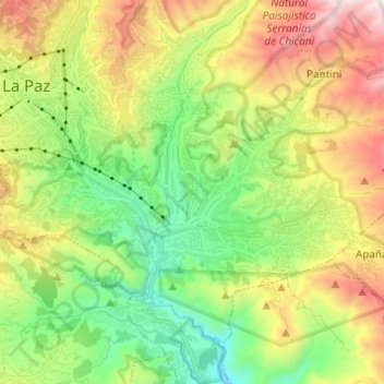
Name: Sur topographic map, elevation, terrain.

Location: Sur, La Paz, Pedro Domingo Murillo, La Paz, Bolivia (-16.56892 -68.14192 -16.48754 -68.01973)

Average elevation: 11,985 ft

Minimum elevation: 10,105 ft

Maximum elevation: 14,993 ft

Other topographic maps

Click on a map to view its topography, its elevation and its terrain.

La Paz

Bolivia > La Paz > Pedro Domingo Murillo > La Paz

The city, in west-central Bolivia 68 km (42 mi) southeast of Lake Titicaca, is set in a canyon created by the Choqueyapu River. It is in a bowl-like depression, part of the Amazon basin, surrounded by the high mountains of the Altiplano. Overlooking the city is the towering, triple-peaked Illimani. Its peaks…

Average elevation: 13,409 ft

Plaza Abaroa

Bolivia > La Paz > Pedro Domingo Murillo > La Paz

Average elevation: 11,732 ft

Laguna Charquini

Bolivia > La Paz > Pedro Domingo Murillo > La Paz

Average elevation: 16,427 ft

Cerro Charkini

Bolivia > La Paz > Pedro Domingo Murillo > La Paz

Average elevation: 16,352 ft

Glaciar Charquini

Bolivia > La Paz > Pedro Domingo Murillo > La Paz

Average elevation: 16,430 ft

Gear up for your next adventure:

🪶Trail Camera - Capture wildlife on your hikes
🧭Compass with Lanyard - Easy‑carry compass for navigation
🚪Portable Camp Chair - Foldable chair for comfort at camp
🔦Compact Flashlight - Reliable flashlight for emergencies
🧥Waterproof Jacket for Hiking - Breathable and rugged rain jacket for outdoor excursions

As an Amazon Associate, this site earns from qualifying purchases at no extra cost to you.