Geolocate

Bangaon topographic map

Click on the map to display elevation.

Bangaon

Bangaon is located at 23°04′N 88°49′E / 23.07°N 88.82°E / 23.07; 88.82. It has an average elevation of 7 metres (22 feet). Arsenic contamination is a major concern in this area.

Wikipedia (CC-BY-SA 3.0)

About this map

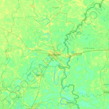
Name: Bangaon topographic map, elevation, terrain.

Location: Bangaon, Bongaon, North 24 Parganas, West Bengal, 743235, India (22.88347 88.67178 23.20347 88.99178)

Average elevation: 23 ft

Minimum elevation: -3 ft

Maximum elevation: 59 ft

Other topographic maps

Click on a map to view its topography, its elevation and its terrain.

Simultala kumortuli Math

India > West Bengal > Bongaon > Bangaon

Average elevation: 33 ft

Gear up for your next adventure:

🔥Plasma Lighters - Windproof lighters that work in any weather condition
🪶Camping Sleeping Pad - Comfortable sleeping pad for backpacking
❄️Traction Cleats - Prevent slips on icy trails during winter hikes
🧭Orienteering Set - Complete compass and map reading kit
🦺Reflective Outdoor Gear - Safety gear for low‑light conditions

As an Amazon Associate, this site earns from qualifying purchases at no extra cost to you.