Geolocate

Miller Cove topographic map

Click on the map to display elevation.

About this map

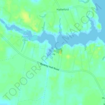
Name: Miller Cove topographic map, elevation, terrain.

Location: Miller Cove, Mathews County, Virginia, 23068, United States (37.48259 -76.34360 37.48269 -76.34350)

Average elevation: 20 ft

Minimum elevation: -13 ft

Maximum elevation: 49 ft

Mathews County trails, hiking, mountain biking, running and outdoor activities

Other topographic maps

Click on a map to view its topography, its elevation and its terrain.

Gwynn's Island

United States > Virginia > Mathews County > Gwynn

Average elevation: 7 ft

Gear up for your next adventure:

💧Water Purification System - Clean water on the trail with reliable purifiers
📖Nature Tracking Books - Learn to track wildlife and terrain
🏥Hiking First Aid Kits - Comprehensive medical kits for remote trail injuries
🧢Outdoor Hiking Hat - Sun protection hat for outdoor explorers
🧭GPS Watch Accessories - Bands and chargers for GPS watches

As an Amazon Associate, this site earns from qualifying purchases at no extra cost to you.