Geolocate

Sukamekar topographic map

Click on the map to display elevation.

About this map

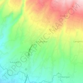
Name: Sukamekar topographic map, elevation, terrain.

Location: Sukamekar, Sukabumi, West Java, Java, 43116, Indonesia (-6.90819 106.92478 -6.86819 106.96478)

Average elevation: 2,608 ft

Minimum elevation: 2,142 ft

Maximum elevation: 3,291 ft

Other topographic maps

Click on a map to view its topography, its elevation and its terrain.

Cibodas

Indonesia > West Java > Sukabumi > Cimenteng

Average elevation: 853 ft

Cikahuripan

Indonesia > West Java > Sukabumi

Average elevation: 361 ft

Cisolok

Indonesia > West Java > Sukabumi

Average elevation: 203 ft

Gear up for your next adventure:

🏕️Family Camping Gear - Essentials for group camping trips
🧭GPS Watch Accessories - Bands and chargers for GPS watches
🥤Water Filter Bottle - All‑in‑one filter bottle for safe hydration
🕶️Glacier Sunglasses - Side shields to protect eyes from high-altitude snow glare
🏕️Tent Footprint - Protect your tent base from wear

As an Amazon Associate, this site earns from qualifying purchases at no extra cost to you.