Geolocate
👉 Easily get elevation data in JSON, GeoTIFF and KML formats using Elevation API
Thank you for supporting this site ❤️
Make a donation

Des Arc topographic map

Click on the map to display elevation.

About this map

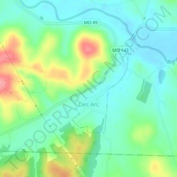
Name: Des Arc topographic map, elevation, terrain.

Location: Des Arc, Iron County, Missouri, United States (37.27823 -90.64081 37.29176 -90.62967)

Average elevation: 610 ft

Minimum elevation: 505 ft

Maximum elevation: 850 ft

Iron County trails, hiking, mountain biking, running and outdoor activities

Other topographic maps

Click on a map to view its topography, its elevation and its terrain.

Belleview

United States > Missouri > Iron County

Average elevation: 1,076 ft

Stony Mountain

United States > Missouri > Iron County

Average elevation: 879 ft

Russellville

United States > Missouri > Iron County > Arcadia

Average elevation: 981 ft

Gear up for your next adventure:

🛡️Insect Repellent - Protection against bugs during outdoor activities
🎒Trekking Poles - Sturdy poles for balance and stability on rough terrain
🧤Tactile Hiking Gloves - Keep hands warm while operating GPS and smartphone screens
🏫Relief Map Kits - Hands-on tools for teaching landforms and elevation
🧭Hiking Compass - Precision compass for reliable navigation in the wilderness

As an Amazon Associate, this site earns from qualifying purchases at no extra cost to you.