Geolocate

Gold Beach topographic map

Click on the map to display elevation.

About this map

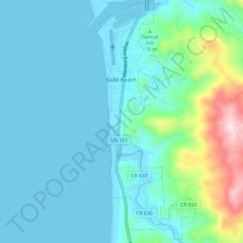
Name: Gold Beach topographic map, elevation, terrain.

Location: Gold Beach, Curry County, Oregon, 97444, United States (42.36717 -124.43122 42.42688 -124.39712)

Average elevation: 279 ft

Minimum elevation: -7 ft

Maximum elevation: 1,752 ft

Curry County trails, hiking, mountain biking, running and outdoor activities

Other topographic maps

Click on a map to view its topography, its elevation and its terrain.

Winchuck

United States > Oregon > Curry County

Average elevation: 302 ft

Langlois

United States > Oregon > Curry County

Average elevation: 190 ft

Cape Blanco

United States > Oregon > Curry County

Average elevation: 26 ft

Big Bend

United States > Oregon > Curry County

Average elevation: 577 ft

Langlois

United States > Oregon > Curry County

Average elevation: 190 ft

Cape Blanco

United States > Oregon > Curry County

Average elevation: 26 ft

Gear up for your next adventure:

👓Polarized Sunglasses - Outdoor sunglasses for glare reduction
🎒Outdoor Daypacks - Lightweight backpacks designed for carrying maps and essential gear
📻Weather Alert Radios - Stay informed of storm risks while off-the-grid
🪶Camping Sleeping Pad - Comfortable sleeping pad for backpacking
🦺Reflective Outdoor Gear - Safety gear for low‑light conditions

As an Amazon Associate, this site earns from qualifying purchases at no extra cost to you.