
Make a donation
Gear up for your next adventure:
As an Amazon Associate, this site earns from qualifying purchases at no extra cost to you.
Langvlei topographic map
Click on the map to display elevation.
Make a donation
Gear up for your next adventure:
As an Amazon Associate, this site earns from qualifying purchases at no extra cost to you.
About this map
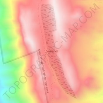
Name: Langvlei topographic map, elevation, terrain.
Average elevation: 2,740 ft
Minimum elevation: 978 ft
Maximum elevation: 3,547 ft
Make a donation
Gear up for your next adventure:
As an Amazon Associate, this site earns from qualifying purchases at no extra cost to you.
Other topographic maps
Click on a map to view its topography, its elevation and its terrain.
Vier en Twintig Riviere
South Africa > Western Cape > West Coast District Municipality > Bergrivier Local Municipality
Average elevation: 938 ft
De Hoek
South Africa > Western Cape > West Coast District Municipality > Bergrivier Local Municipality
Average elevation: 531 ft
Eendekuil
South Africa > Western Cape > West Coast District Municipality > Bergrivier Local Municipality
Average elevation: 387 ft
Dwarskersbos
South Africa > Western Cape > West Coast District Municipality > Bergrivier Local Municipality
Average elevation: 16 ft
Make a donation
Gear up for your next adventure:
As an Amazon Associate, this site earns from qualifying purchases at no extra cost to you.