Geolocate

Trimountain topographic map

Click on the map to display elevation.

About this map

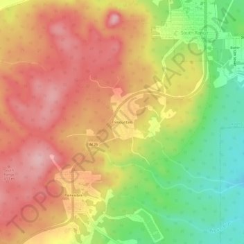
Name: Trimountain topographic map, elevation, terrain.

Location: Trimountain, Adams Township, Houghton County, Michigan, 49955, United States (47.03521 -88.68068 47.07521 -88.64068)

Average elevation: 1,257 ft

Minimum elevation: 951 ft

Maximum elevation: 1,486 ft

Houghton County trails, hiking, mountain biking, running and outdoor activities

Other topographic maps

Click on a map to view its topography, its elevation and its terrain.

Lake Linden

United States > Michigan > Houghton County

Average elevation: 676 ft

Copper City

United States > Michigan > Houghton County

Average elevation: 892 ft

Laurium

United States > Michigan > Houghton County

Average elevation: 1,201 ft

Elm River Township

United States > Michigan > Houghton County

Average elevation: 1,145 ft

Gear up for your next adventure:

🚑Emergency Bivvies - Heat-reflective sleeping bags for survival situations
🥾Hiking Shoes - Durable and comfortable shoes for trail hiking
📌Outdoor GPS Map App - Apps and devices for digital topographic navigation
🔋Rechargeable Batteries - Power up your outdoor devices
🌡️Handheld Weather Meters - Measure wind, temp, and pressure for safe mountain travel

As an Amazon Associate, this site earns from qualifying purchases at no extra cost to you.