Geolocate

Thackery topographic map

Click on the map to display elevation.

About this map

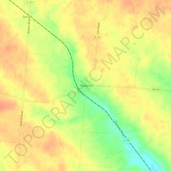
Name: Thackery topographic map, elevation, terrain.

Location: Thackery, Champaign County, Ohio, United States (40.03561 -83.93882 40.07561 -83.89882)

Average elevation: 1,158 ft

Minimum elevation: 1,060 ft

Maximum elevation: 1,207 ft

Champaign County trails, hiking, mountain biking, running and outdoor activities

Other topographic maps

Click on a map to view its topography, its elevation and its terrain.

North Lewisburg

United States > Ohio > Champaign County

Average elevation: 1,099 ft

Woodstock

United States > Ohio > Champaign County

Average elevation: 1,050 ft

Mutual

United States > Ohio > Champaign County

Average elevation: 1,204 ft

Mechanicsburg

United States > Ohio > Champaign County

Average elevation: 1,089 ft

Mad River

United States > Ohio > Champaign County > West Liberty

Average elevation: 1,106 ft

St. Paris

United States > Ohio > Champaign County

Average elevation: 1,224 ft

Christiansburg

United States > Ohio > Champaign County

Average elevation: 1,122 ft

Gear up for your next adventure:

🔦Powerful Headlamps - Ultra-bright hands-free lighting for night navigation
Camping Coffee Makers - Enjoy premium coffee at the summit or campsite
🌧️Backpack Rain Cover - Keep gear dry in wet weather
📱Heavy-Duty Phone Cases - Drop-proof and waterproof protection for outdoor navigation
🧢Outdoor Hiking Hat - Sun protection hat for outdoor explorers

As an Amazon Associate, this site earns from qualifying purchases at no extra cost to you.