
Make a donation
Gear up for your next adventure:
As an Amazon Associate, this site earns from qualifying purchases at no extra cost to you.
Skegness topographic map
Click on the map to display elevation.
Make a donation
Gear up for your next adventure:
As an Amazon Associate, this site earns from qualifying purchases at no extra cost to you.
Skegness
Skegness fronts the North Sea. It is located on a low-lying flat region called Lincoln Marsh, which runs along the coast between Skegness and the Humber and separates the coast from the upland Wolds. Much of the parish's elevation is close to sea level, although a narrow band along the seafront is 4–5 m (13–16 ft) above peaking at 6 m (20 ft) on North Parade; the A52 road is elevated at 4 m (13 ft); and there is also a short narrow bank parallel to the shoreline between the North Shore Golf Club and Seathorne which is 10 m (33 ft) above sea level.
Make a donation
Gear up for your next adventure:
As an Amazon Associate, this site earns from qualifying purchases at no extra cost to you.
About this map
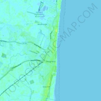
Name: Skegness topographic map, elevation, terrain.
Location: Skegness, East Lindsey, Lincolnshire, England, United Kingdom (53.12018 0.29858 53.18005 0.35683)
Average elevation: 7 ft
Minimum elevation: -16 ft
Maximum elevation: 39 ft
Make a donation
Gear up for your next adventure:
As an Amazon Associate, this site earns from qualifying purchases at no extra cost to you.
Other topographic maps
Click on a map to view its topography, its elevation and its terrain.
Saltfleetby St Peter
United Kingdom > England > Lincolnshire > East Lindsey > Saltfleetby St Peter
Average elevation: 10 ft