
Make a donation
Gear up for your next adventure:
As an Amazon Associate, this site earns from qualifying purchases at no extra cost to you.
Bargenstedt topographic map
Click on the map to display elevation.
Make a donation
Gear up for your next adventure:
As an Amazon Associate, this site earns from qualifying purchases at no extra cost to you.
Bargenstedt
Das Bild der auf einem Berg stehenden Häuser im Wappen der Gemeinde Bargenstedt bezieht sich auf die topographische Situation des Ortsteils Bargenstedt auf einem hochgelegenen Geestrücken. Mit Rücksicht auf die mögliche, sprachwissenschaftlich allerdings nicht eindeutig belegbare Deutung des Ortsnamens als „Stätte auf den Bergen“ kann das Gemeindewappen aber auch als „redendes“ Wahrzeichen in Anspruch genommen werden. Der Ortsteil Dellbrück wird durch ein vorgeschichtliches Steingrab im Schildfuß vertreten. Dieses Hünengrab ist auch heute noch erhalten.
Make a donation
Gear up for your next adventure:
As an Amazon Associate, this site earns from qualifying purchases at no extra cost to you.
About this map
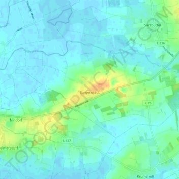
Name: Bargenstedt topographic map, elevation, terrain.
Average elevation: 23 ft
Minimum elevation: -7 ft
Maximum elevation: 105 ft
Make a donation
Gear up for your next adventure:
As an Amazon Associate, this site earns from qualifying purchases at no extra cost to you.
Other topographic maps
Click on a map to view its topography, its elevation and its terrain.
Make a donation
Gear up for your next adventure:
As an Amazon Associate, this site earns from qualifying purchases at no extra cost to you.
WKK Ententeich
Deutschland > Schleswig-Holstein > Dithmarschen > Heide > Hochfeld
Average elevation: 26 ft
Make a donation
Gear up for your next adventure:
As an Amazon Associate, this site earns from qualifying purchases at no extra cost to you.
Make a donation
Gear up for your next adventure:
As an Amazon Associate, this site earns from qualifying purchases at no extra cost to you.
Zippelkoog
Deutschland > Schleswig-Holstein > Dithmarschen > Helse > Zippelkoog
Average elevation: 3 ft
Make a donation
Gear up for your next adventure:
As an Amazon Associate, this site earns from qualifying purchases at no extra cost to you.
Poppenwurth
Deutschland > Schleswig-Holstein > Dithmarschen > Oesterwurth > Poppenwurth
Average elevation: 7 ft
Make a donation
Gear up for your next adventure:
As an Amazon Associate, this site earns from qualifying purchases at no extra cost to you.
Oldörpen
Deutschland > Schleswig-Holstein > Dithmarschen > Tensbüttel-Röst > Tensbüttel > Oldörpen
Average elevation: 56 ft