
Französisch Buchholz topographic map
Interactive map
Click on the map to display elevation.
About this map
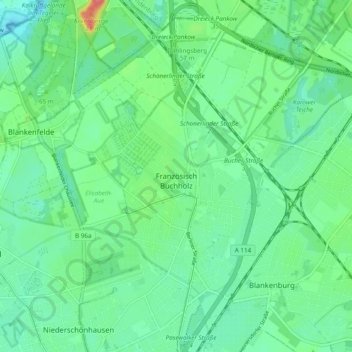
Name: Französisch Buchholz topographic map, elevation, terrain.
Location: Französisch Buchholz, Pankow, Berlin, 13127, Allemagne (52.58215 13.41197 52.64042 13.46896)
Average elevation: 167 ft
Minimum elevation: 112 ft
Maximum elevation: 322 ft
Other topographic maps
Click on a map to view its topography, its elevation and its terrain.
Marzahn-Hellersdorf
Marzahn-Hellersdorf, Berlin, Allemagne
Average elevation: 171 ft
Steglitz-Zehlendorf
Steglitz-Zehlendorf, Berlin, Allemagne
Average elevation: 148 ft
Tempelhof-Schöneberg
Tempelhof-Schöneberg, Berlin, Allemagne
Average elevation: 148 ft
Charlottenburg-Wilmersdorf
Charlottenburg-Wilmersdorf, Berlin, Allemagne
Average elevation: 144 ft
Blankenfelde
Blankenfelde, Pankow, Berlin, 13159, Allemagne
Average elevation: 164 ft
Charlottenburg
Charlottenburg, Charlottenburg-Wilmersdorf, Berlin, Allemagne
Average elevation: 135 ft
Schöneberg
Schöneberg, Tempelhof-Schöneberg, Berlin, Allemagne
Average elevation: 151 ft
Müggelheim
Allemagne > Berlin > Karolinenhof
Müggelheim, Treptow-Köpenick, Karolinenhof, Berlin, Allemagne
Average elevation: 125 ft