
Machupicchu Pueblo topographic map
Interactive map
Click on the map to display elevation.
About this map
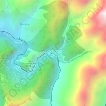
Name: Machupicchu Pueblo topographic map, elevation, terrain.
Average elevation: 8,182 ft
Minimum elevation: 6,240 ft
Maximum elevation: 11,759 ft
Other topographic maps
Click on a map to view its topography, its elevation and its terrain.
Machu Picchu
Peru > Cusco > Machupicchu > San Miguel
Machu Picchu, Path to Inka Bridge, San Miguel, Machupicchu, Province of Urubamba, Cusco, 08680, Peru
Average elevation: 7,306 ft
San Miguel
Peru > Cusco > Machupicchu > Intihuatana
San Miguel, Intihuatana, Machupicchu, Province of Urubamba, Cusco, 08680, Peru
Average elevation: 7,421 ft
Machupicchu
Peru > Cusco > Machupicchu
Machupicchu, Province of Urubamba, Cusco, Peru
Average elevation: 11,942 ft