Geolocate

Knocknarea topographic map

Click on the map to display elevation.

About this map
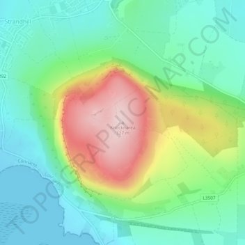
Name: Knocknarea topographic map, elevation, terrain.

Location: Knocknarea, Sligo Municipal Borough District, County Sligo, Connacht, F91 V8YY, Ireland (54.25871 -8.57455 54.25881 -8.57445)

Average elevation: 341 ft

Minimum elevation: 0 ft

Maximum elevation: 1,047 ft

Other topographic maps

Click on a map to view its topography, its elevation and its terrain.

Sligo

Ireland > County Sligo

Average elevation: 69 ft

Ballintogher

Ireland > County Sligo

Average elevation: 210 ft

Rosses Upper

Ireland > County Sligo

Average elevation: 26 ft

Markree Castle

Ireland > County Sligo

Average elevation: 118 ft

Carrowntemple

Ireland > County Sligo

Average elevation: 423 ft

Doonbeakin

Ireland > County Sligo

Average elevation: 348 ft

Bartragh

Ireland > County Sligo

Average elevation: 20 ft

Carrowbunnaun

Ireland > County Sligo

Average elevation: 118 ft

Carrownanty

Ireland > County Sligo

Average elevation: 243 ft

Ballysumaghan

Ireland > County Sligo

Average elevation: 233 ft

Rosses Point

Ireland > County Sligo

Average elevation: 26 ft

Bearlough

Ireland > County Sligo

Average elevation: 236 ft

Gear up for your next adventure:

🏕️Family Camping Gear - Essentials for group camping trips
🔦Compact Flashlight - Reliable flashlight for emergencies
🏫Relief Map Kits - Hands-on tools for teaching landforms and elevation
🧭Map Reading Tools - Tools and kits for map navigation
🦶Hiking Gaiters - Keep debris and water out of your boots

As an Amazon Associate, this site earns from qualifying purchases at no extra cost to you.