
Make a donation
Gear up for your next adventure:
As an Amazon Associate, this site earns from qualifying purchases at no extra cost to you.
Verdú topographic map
Click on the map to display elevation.
Make a donation
Gear up for your next adventure:
As an Amazon Associate, this site earns from qualifying purchases at no extra cost to you.
About this map
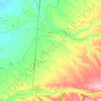
Name: Verdú topographic map, elevation, terrain.
Location: Verdú, Urgel, Lérida, Cataluña, 25340, España (41.56766 1.07724 41.62488 1.18002)
Average elevation: 1,490 ft
Minimum elevation: 1,086 ft
Maximum elevation: 2,077 ft
Make a donation
Gear up for your next adventure:
As an Amazon Associate, this site earns from qualifying purchases at no extra cost to you.
Other topographic maps
Click on a map to view its topography, its elevation and its terrain.
Make a donation
Gear up for your next adventure:
As an Amazon Associate, this site earns from qualifying purchases at no extra cost to you.
Bellpuig
España > Cataluña > Urgel > Bellpuig > Bellpuig
El relieve del municipio es predominantemente llano, discurriendo en su territorio el Canal de Urgel, necesario para el regadío, además del río Corb y varias acequias. El sector del término que es un poco montañoso es el que está ocupado por el municipio y las colinas que se extienden al este. La altitud…
Average elevation: 991 ft
Make a donation
Gear up for your next adventure:
As an Amazon Associate, this site earns from qualifying purchases at no extra cost to you.