
Thank you for supporting this site ❤️
Make a donation
Make a donation
Gear up for your next adventure:
As an Amazon Associate, this site earns from qualifying purchases at no extra cost to you.
Estoril topographic map
Click on the map to display elevation.
Thank you for supporting this site ❤️
Make a donation
Make a donation
Gear up for your next adventure:
As an Amazon Associate, this site earns from qualifying purchases at no extra cost to you.
About this map
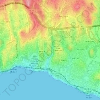
Name: Estoril topographic map, elevation, terrain.
Location: Estoril, Galiza, Cascais e Estoril, Cascais, Lisbon, Portugal (38.69207 -9.41303 38.72735 -9.36656)
Average elevation: 161 ft
Minimum elevation: 0 ft
Maximum elevation: 427 ft
Thank you for supporting this site ❤️
Make a donation
Make a donation
Gear up for your next adventure:
As an Amazon Associate, this site earns from qualifying purchases at no extra cost to you.