
Make a donation
Gear up for your next adventure:
As an Amazon Associate, this site earns from qualifying purchases at no extra cost to you.
Cagnes-sur-Mer topographic map
Click on the map to display elevation.
Make a donation
Gear up for your next adventure:
As an Amazon Associate, this site earns from qualifying purchases at no extra cost to you.
Cagnes-sur-Mer
The municipality covers an area of 1,795 hectares; the elevation ranges from 0 to 187 meters. It is classified as seismic zone 4 (moderate seismicity) and some earthquakes are felt in Cagnes-sur-Mer.
Make a donation
Gear up for your next adventure:
As an Amazon Associate, this site earns from qualifying purchases at no extra cost to you.
About this map
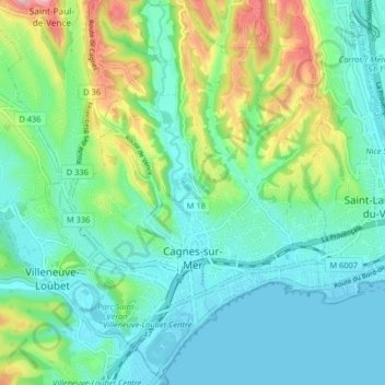
Name: Cagnes-sur-Mer topographic map, elevation, terrain.
Average elevation: 187 ft
Minimum elevation: -3 ft
Maximum elevation: 741 ft
Make a donation
Gear up for your next adventure:
As an Amazon Associate, this site earns from qualifying purchases at no extra cost to you.
Other topographic maps
Click on a map to view its topography, its elevation and its terrain.
Mont Agel
France > Provence-Alpes-Côte d'Azur > Maritime Alps > Peille
Mont Agel is a mountain in the Maritime Alps on the border between France and Monaco. The summit of this mount, at 1,148 metres (3,766 ft) above sea level, is on the French side, but the highest point of Monaco, lying on a pathway named Chemin des Révoires, is on its slopes, at an altitude of 161 metres (528…
Average elevation: 2,592 ft
Cime de Campbel
France > Provence-Alpes-Côte d'Azur > Maritime Alps > Fontan
Average elevation: 3,163 ft
Puget-Théniers
France > Provence-Alpes-Côte d'Azur > Maritime Alps > Puget-Théniers
Average elevation: 2,257 ft
Make a donation
Gear up for your next adventure:
As an Amazon Associate, this site earns from qualifying purchases at no extra cost to you.
La Redoute des 3 Communes
France > Provence-Alpes-Côte d'Azur > Maritime Alps > Moulinet
Average elevation: 5,705 ft
Saint Antoine
France > Provence-Alpes-Côte d'Azur > Maritime Alps > Sospel
Average elevation: 1,883 ft
Make a donation
Gear up for your next adventure:
As an Amazon Associate, this site earns from qualifying purchases at no extra cost to you.
Col de Turini
France > Provence-Alpes-Côte d'Azur > Maritime Alps > Moulinet
Average elevation: 5,082 ft
Make a donation
Gear up for your next adventure:
As an Amazon Associate, this site earns from qualifying purchases at no extra cost to you.
Gorgia
France > Provence-Alpes-Côte d'Azur > Maritime Alps > Saint-Étienne-de-Tinée
Average elevation: 4,964 ft
Auron
France > Provence-Alpes-Côte d'Azur > Maritime Alps > Saint-Étienne-de-Tinée
Auron is a ski resort in the department of Alpes-Maritimes and the region of Provence-Alpes-Côte d'Azur in France. The resort has 135 kilometres (84 mi) of ski runs, at an elevation of between 1,600 and 2,450 m (5,250 and 8,040 ft) in the French Alps. It is located above the Tinée Valley near the town of…
Average elevation: 5,427 ft
Sainte-Claire
France > Provence-Alpes-Côte d'Azur > Maritime Alps > Guillaumes
Average elevation: 3,488 ft
Make a donation
Gear up for your next adventure:
As an Amazon Associate, this site earns from qualifying purchases at no extra cost to you.
La Madone
France > Provence-Alpes-Côte d'Azur > Maritime Alps > Saint-Martin-Vésubie
Average elevation: 3,776 ft
Mont Agel
France > Provence-Alpes-Côte d'Azur > Maritime Alps > Peille
Mont Agel is a mountain on the border between France and Monaco. The summit of this mount, at 1,148 metres (3,766 ft) above sea level, is on the French side, but the highest point of Monaco, lying on a pathway named Chemin des Révoires, is on its slopes, at an altitude of 161 metres (528 feet).
Average elevation: 2,592 ft
Make a donation
Gear up for your next adventure:
As an Amazon Associate, this site earns from qualifying purchases at no extra cost to you.
Cannes
France > Provence-Alpes-Côte d'Azur > Maritime Alps > Cannes > Cannes
Average elevation: 177 ft
Make a donation
Gear up for your next adventure:
As an Amazon Associate, this site earns from qualifying purchases at no extra cost to you.
Réca Véssas
France > Provence-Alpes-Côte d'Azur > Maritime Alps > Clans > Bancairon
Average elevation: 2,051 ft