Geolocate

Rawang topographic map

Click on the map to display elevation.

About this map

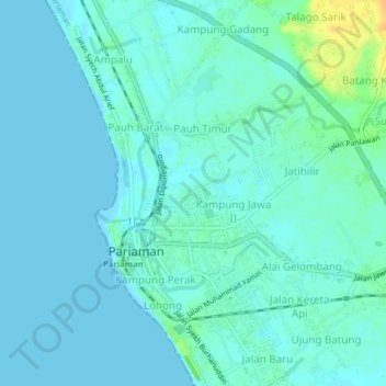
Name: Rawang topographic map, elevation, terrain.

Location: Rawang, Pariaman, West Sumatra, Sumatra, 25518, Indonesia (-0.64031 100.10372 -0.60031 100.14372)

Average elevation: 20 ft

Minimum elevation: -3 ft

Maximum elevation: 98 ft

Gear up for your next adventure:

🩳Quick‑Dry Hiking Shorts - Comfortable and quick‑dry shorts for summer hiking
😴Insulated Sleeping Pads - Compact and warm pads for high-elevation camping
📡GPS Antenna Upgrade - Enhance GPS reception in remote terrain
🧭Pro Hiking Compasses - High-accuracy liquid-filled compasses for topographic orientation
🧢Sun Protection Hats - Wide-brimmed and UPF-rated hats for high-altitude sun safety

As an Amazon Associate, this site earns from qualifying purchases at no extra cost to you.