
Make a donation
Gear up for your next adventure:
As an Amazon Associate, this site earns from qualifying purchases at no extra cost to you.
Conneaut Lake topographic map
Click on the map to display elevation.
Make a donation
Gear up for your next adventure:
As an Amazon Associate, this site earns from qualifying purchases at no extra cost to you.
About this map
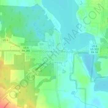
Name: Conneaut Lake topographic map, elevation, terrain.
Location: Conneaut Lake, Crawford County, Pennsylvania, United States (41.59654 -80.31992 41.60890 -80.30105)
Average elevation: 1,109 ft
Minimum elevation: 1,056 ft
Maximum elevation: 1,230 ft
Crawford County trails, hiking, mountain biking, running and outdoor activities
Make a donation
Gear up for your next adventure:
As an Amazon Associate, this site earns from qualifying purchases at no extra cost to you.
Other topographic maps
Click on a map to view its topography, its elevation and its terrain.
Teepleville
United States > Pennsylvania > Crawford County > Richmond Township
Average elevation: 1,266 ft
Franklin Pike Corners
United States > Pennsylvania > Crawford County > West Mead Township
Average elevation: 1,237 ft
Make a donation
Gear up for your next adventure:
As an Amazon Associate, this site earns from qualifying purchases at no extra cost to you.