
Make a donation
Gear up for your next adventure:
As an Amazon Associate, this site earns from qualifying purchases at no extra cost to you.
Lockwood Peak topographic map
Click on the map to display elevation.
Make a donation
Gear up for your next adventure:
As an Amazon Associate, this site earns from qualifying purchases at no extra cost to you.
About this map
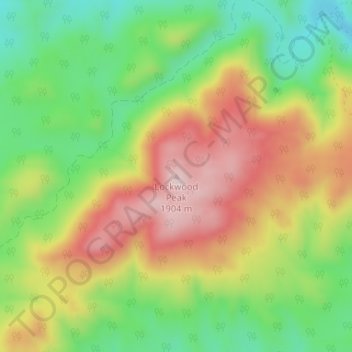
Name: Lockwood Peak topographic map, elevation, terrain.
Location: Lockwood Peak, Ventura County, California, United States (34.70954 -119.06972 34.70964 -119.06962)
Average elevation: 5,679 ft
Minimum elevation: 5,187 ft
Maximum elevation: 6,243 ft
Ventura County trails, hiking, mountain biking, running and outdoor activities
Make a donation
Gear up for your next adventure:
As an Amazon Associate, this site earns from qualifying purchases at no extra cost to you.
Other topographic maps
Click on a map to view its topography, its elevation and its terrain.
Santa Paula
United States > California > Ventura County
On October 31, 2019, the Maria Fire was reported burning at the top of South Mountain between Santa Paula and Somis and expanded throughout that evening. Heavily influenced by 20–30 mph (32–48 km/h) winds within the canyons, the fire became a full scale conflagration, growing from 50 to 750 acres (20 to…
Average elevation: 479 ft
Camarillo
United States > California > Ventura County
In the mid-1950s, the Ventura Freeway was completed from Los Angeles to points north, making it an easy one-hour trip to Camarillo. The Old Town was bisect by the Ventura Freeway. On the southern side of the freeway contains a strip of businesses, churches, schools, and parks. The freeway was originally…
Average elevation: 295 ft
Simi Valley
United States > California > Ventura County
Simi Valley is a city located in the very southeast corner of Ventura County, bordering the San Fernando Valley in Los Angeles County, and is a part of the Greater Los Angeles Area. The city of Simi Valley basically consists of the eponymous valley itself. The city of Simi Valley borders the Santa Susana…
Average elevation: 1,329 ft
Make a donation
Gear up for your next adventure:
As an Amazon Associate, this site earns from qualifying purchases at no extra cost to you.
Simi Valley
United States > California > Ventura County
Simi Valley is a city located in the very southeast corner of Ventura County, bordering the San Fernando Valley in Los Angeles County, and is a part of the Greater Los Angeles Area. The city of Simi Valley basically consists of the eponymous valley itself. The city of Simi Valley borders the Santa Susana…
Average elevation: 1,329 ft
Ojai
United States > California > Ventura County
Nordhoff Ridge, the western extension of the Topatopa Mountains, towers over the north side of the valley at more than 5,000 feet (1,500 m). Sulphur Mountain creates the southern ranges bounding the Ojai Valley, a little under 3,000 feet (910 m) in elevation. The Sulphur and Topatopa mountains are part of the…
Average elevation: 948 ft
Make a donation
Gear up for your next adventure:
As an Amazon Associate, this site earns from qualifying purchases at no extra cost to you.
Lake Piru
United States > California > Ventura County
The elevation of the reservoir is 1,043 ft (318 m), and the elevation of the dam spillway is 1,055 ft (322 m). The dam is owned and operated by the United Water Conservation District based in nearby Santa Paula, California. The district is a multi-service district providing flood control, recreation services,…
Average elevation: 1,230 ft
Thousand Oaks
United States > California > Ventura County
The northern parts consist of mountainous terrain in the Simi Hills, Conejo Mountains and Mount Clef Ridge. Narrow canyons such as Hill Canyon cut through the steeper mountainous areas. Conejo Mountain and Conejo Grade are found in westernmost Newbury Park, while the southernmost parts of Thousand Oaks are…
Average elevation: 1,093 ft
Make a donation
Gear up for your next adventure:
As an Amazon Associate, this site earns from qualifying purchases at no extra cost to you.
Ojai
United States > California > Ventura County
Nordhoff Ridge, the western extension of the Topatopa Mountains, towers over the north side of the valley at more than 5,000 feet (1,500 m). Sulphur Mountain creates the southern ranges bounding the Ojai Valley, a little under 3,000 feet (910 m) in elevation. The Sulphur and Topatopa mountains are part of the…
Average elevation: 948 ft
Anacapa Island
United States > California > Ventura County
West Anacapa is the largest and highest islet, rising to an altitude of 930 ft (283 m) at Vela Peak, also known as Summit Peak 2. East and Middle Anacapa have fairly level areas at their tops. Middle Island reaches an altitude of 325 ft (99 m) and East Island is 250 ft (76 m) at its highest point. All three…
Average elevation: 13 ft
Make a donation
Gear up for your next adventure:
As an Amazon Associate, this site earns from qualifying purchases at no extra cost to you.
Simi Valley
United States > California > Ventura County
Simi Valley is a city located in the very southeast corner of Ventura County, bordering the San Fernando Valley in Los Angeles County, and is a part of the Greater Los Angeles Area. The city of Simi Valley basically consists of the eponymous valley itself. The city of Simi Valley borders the Santa Susana…
Average elevation: 1,329 ft
Wildwood Park
United States > California > Ventura County > Thousand Oaks
At Lizard Rock, Teepee Overlook, and similar higher elevation areas, there are panoramic views of the Conejo Valley.
Average elevation: 528 ft
Make a donation
Gear up for your next adventure:
As an Amazon Associate, this site earns from qualifying purchases at no extra cost to you.
San Nicolas Island
United States > California > Ventura County
The highest point is Jackson Hill, with an elevation of 907 feet (276 m) above sea level.
Average elevation: 125 ft
Make a donation
Gear up for your next adventure:
As an Amazon Associate, this site earns from qualifying purchases at no extra cost to you.
Thousand Oaks
United States > California > Ventura County
The northern parts consist of mountainous terrain in the Simi Hills, Conejo Mountains and Mount Clef Ridge. Narrow canyons such as Hill Canyon cut through the steeper mountainous areas. Conejo Mountain and Conejo Grade are found in westernmost Newbury Park, while the southernmost parts of Thousand Oaks are…
Average elevation: 1,093 ft
Channel Islands Beach
United States > California > Ventura County > Silver Strand
Average elevation: 10 ft
Make a donation
Gear up for your next adventure:
As an Amazon Associate, this site earns from qualifying purchases at no extra cost to you.
Make a donation
Gear up for your next adventure:
As an Amazon Associate, this site earns from qualifying purchases at no extra cost to you.
Santa Paula
United States > California > Ventura County
On October 31, 2019, the Maria Fire was reported burning at the top of South Mountain between Santa Paula and Somis and expanded throughout that evening. Heavily influenced by 20–30 mph (32–48 km/h) winds within the canyons, the fire became a full scale conflagration, growing from 50 to 750 acres (20 to…
Average elevation: 486 ft
Johnson Creek Park
United States > California > Ventura County > Oxnard > Pleasant Valley Mobile Home Park
Average elevation: 33 ft