Geolocate

Katraj topographic map

Click on the map to display elevation.

About this map

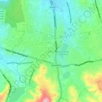
Name: Katraj topographic map, elevation, terrain.

Location: Katraj, Pune, Maharashtra, 411046, India (18.43368 73.83632 18.47368 73.87632)

Average elevation: 2,172 ft

Minimum elevation: 1,982 ft

Maximum elevation: 2,615 ft

Other topographic maps

Click on a map to view its topography, its elevation and its terrain.

Katraj Lake

India > Maharashtra > Pune > Katraj

Average elevation: 2,172 ft

Gear up for your next adventure:

🎒Day Hiking Backpack - Lightweight backpack perfect for day trips and outdoor adventures
🎒Hydration Pack - Hands‑free water reservoir for long hikes
🖼️Topo Map Wall Art - Decorative topographic prints of famous peaks and regions
🛰️Satellite Messengers - Emergency SOS and two-way messaging for off-grid adventures
🧭Compass with Lanyard - Easy‑carry compass for navigation

As an Amazon Associate, this site earns from qualifying purchases at no extra cost to you.