
Höchstädt topographic map
Interactive map
Click on the map to display elevation.
About this map
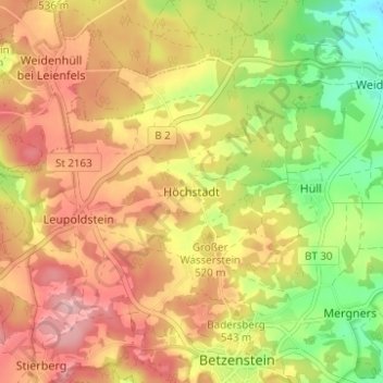
Name: Höchstädt topographic map, elevation, terrain.
Average elevation: 1,703 ft
Minimum elevation: 1,430 ft
Maximum elevation: 1,923 ft
Das Dorf befindet sich etwa zwei Kilometer nordnordwestlich von Betzenstein auf einer Höhe von 521 m ü. NHN.
Other topographic maps
Click on a map to view its topography, its elevation and its terrain.
Eichenstruth
Deutschland > Bayern > Landkreis Bayreuth > Betzenstein
Eichenstruth, Betzenstein, Betzenstein (VGem), Landkreis Bayreuth, Bayern, 91287, Deutschland
Average elevation: 1,657 ft
Leupoldstein
Deutschland > Bayern > Landkreis Bayreuth > Betzenstein
Leupoldstein, Betzenstein, Betzenstein (VGem), Landkreis Bayreuth, Bayern, 91282, Deutschland
Average elevation: 1,749 ft