
Thank you for supporting this site ❤️
Make a donation
Make a donation
Gear up for your next adventure:
As an Amazon Associate, this site earns from qualifying purchases at no extra cost to you.
Leupoldstein topographic map
Click on the map to display elevation.
Thank you for supporting this site ❤️
Make a donation
Make a donation
Gear up for your next adventure:
As an Amazon Associate, this site earns from qualifying purchases at no extra cost to you.
Leupoldstein
Das im Norden der Pegnitz-Kuppenalb gelegene Dorf befindet sich etwa zweieinhalb Kilometer nordwestlich des Ortszentrums von Betzenstein und liegt auf einer Höhe von 547 m ü. NHN.
Thank you for supporting this site ❤️
Make a donation
Make a donation
Gear up for your next adventure:
As an Amazon Associate, this site earns from qualifying purchases at no extra cost to you.
About this map
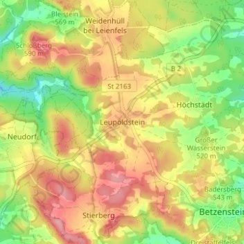
Name: Leupoldstein topographic map, elevation, terrain.
Average elevation: 1,749 ft
Minimum elevation: 1,545 ft
Maximum elevation: 1,929 ft
Thank you for supporting this site ❤️
Make a donation
Make a donation
Gear up for your next adventure:
As an Amazon Associate, this site earns from qualifying purchases at no extra cost to you.