
Make a donation
Gear up for your next adventure:
As an Amazon Associate, this site earns from qualifying purchases at no extra cost to you.
Oakwood topographic map
Click on the map to display elevation.
Make a donation
Gear up for your next adventure:
As an Amazon Associate, this site earns from qualifying purchases at no extra cost to you.
About this map
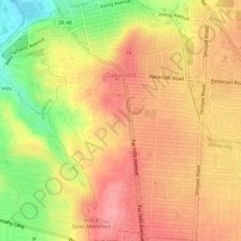
Name: Oakwood topographic map, elevation, terrain.
Location: Oakwood, Montgomery County, Ohio, 45419, United States (39.70477 -84.19051 39.73453 -84.16064)
Average elevation: 919 ft
Minimum elevation: 715 ft
Maximum elevation: 1,040 ft
Montgomery County trails, hiking, mountain biking, running and outdoor activities
Make a donation
Gear up for your next adventure:
As an Amazon Associate, this site earns from qualifying purchases at no extra cost to you.
Other topographic maps
Click on a map to view its topography, its elevation and its terrain.
Miamisburg Community Park
United States > Ohio > Montgomery County > Miamisburg
Average elevation: 791 ft
Boone Island (historical)
United States > Ohio > Montgomery County > West Carrollton
Average elevation: 906 ft
Make a donation
Gear up for your next adventure:
As an Amazon Associate, this site earns from qualifying purchases at no extra cost to you.
Make a donation
Gear up for your next adventure:
As an Amazon Associate, this site earns from qualifying purchases at no extra cost to you.
Centerville
United States > Ohio > Montgomery County > Centerville > Centerville
Average elevation: 945 ft
Make a donation
Gear up for your next adventure:
As an Amazon Associate, this site earns from qualifying purchases at no extra cost to you.
Make a donation
Gear up for your next adventure:
As an Amazon Associate, this site earns from qualifying purchases at no extra cost to you.
Miamisburg
United States > Ohio > Montgomery County > Miamisburg > Miamisburg
Average elevation: 804 ft
Make a donation
Gear up for your next adventure:
As an Amazon Associate, this site earns from qualifying purchases at no extra cost to you.