
Thank you for supporting this site ❤️
Make a donation
Make a donation
Gear up for your next adventure:
As an Amazon Associate, this site earns from qualifying purchases at no extra cost to you.
Collarada topographic map
Click on the map to display elevation.
Thank you for supporting this site ❤️
Make a donation
Make a donation
Gear up for your next adventure:
As an Amazon Associate, this site earns from qualifying purchases at no extra cost to you.
About this map
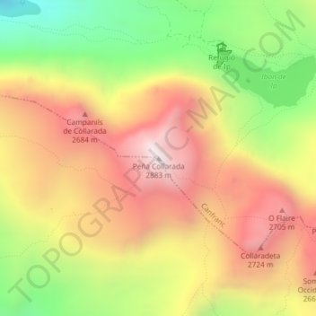
Name: Collarada topographic map, elevation, terrain.
Location: Collarada, Canfranc, La Jacetania, Huesca, Aragón, España (42.71417 -0.47068 42.71427 -0.47058)
Average elevation: 7,677 ft
Minimum elevation: 5,673 ft
Maximum elevation: 9,423 ft
Thank you for supporting this site ❤️
Make a donation
Make a donation
Gear up for your next adventure:
As an Amazon Associate, this site earns from qualifying purchases at no extra cost to you.