
Thank you for supporting this site ❤️
Make a donation
Make a donation
Gear up for your next adventure:
As an Amazon Associate, this site earns from qualifying purchases at no extra cost to you.
Lumaco topographic map
Click on the map to display elevation.
Thank you for supporting this site ❤️
Make a donation
Make a donation
Gear up for your next adventure:
As an Amazon Associate, this site earns from qualifying purchases at no extra cost to you.
About this map
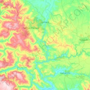
Name: Lumaco topographic map, elevation, terrain.
Location: Lumaco, Provincia de Malleco, Araucanie, 4740000, Chili (-38.48017 -73.34108 -38.07037 -72.78741)
Average elevation: 909 ft
Minimum elevation: 79 ft
Maximum elevation: 2,766 ft
Thank you for supporting this site ❤️
Make a donation
Make a donation
Gear up for your next adventure:
As an Amazon Associate, this site earns from qualifying purchases at no extra cost to you.