Geolocate

Leon topographic map

Click on the map to display elevation.

About this map

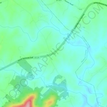
Name: Leon topographic map, elevation, terrain.

Location: Leon, Madison County, Virginia, 22725, United States (38.41763 -78.15833 38.45763 -78.11833)

Average elevation: 522 ft

Minimum elevation: 404 ft

Maximum elevation: 955 ft

Madison County trails, hiking, mountain biking, running and outdoor activities

Other topographic maps

Click on a map to view its topography, its elevation and its terrain.

Blakey Ridge

United States > Virginia > Madison County

Average elevation: 1,362 ft

Gear up for your next adventure:

🧣Merino Neck Gaiters - Multi-functional headwear for wind and sun protection
📌Outdoor GPS Map App - Apps and devices for digital topographic navigation
🎒Gear Packing Cubes - Organize your backpack efficiently
🥾Men's Hiking Boots - Durable, waterproof footwear for rugged terrain and steep inclines
📦Dry Bags Set - Waterproof storage for electronics and clothes

As an Amazon Associate, this site earns from qualifying purchases at no extra cost to you.