Geolocate

Capalonga topographic map

Click on the map to display elevation.

About this map

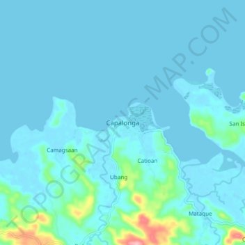
Name: Capalonga topographic map, elevation, terrain.

Location: Capalonga, Camarines Norte, Bicol Region, 4607, Philippines (14.29104 122.45247 14.37104 122.53247)

Average elevation: 43 ft

Minimum elevation: -13 ft

Maximum elevation: 476 ft

Other topographic maps

Click on a map to view its topography, its elevation and its terrain.

Daet River

Philippines > Camarines Norte > Daet > Bibirao

Average elevation: 62 ft

Daet River

Philippines > Camarines Norte > Daet

Average elevation: 10 ft

Bagasbas Beach

Philippines > Camarines Norte > Daet

Average elevation: 3 ft

Vinzons

Philippines > Camarines Norte

Average elevation: 33 ft

Paracale

Philippines > Camarines Norte

Average elevation: 36 ft

Gear up for your next adventure:

🧣Hiking Neck Gaiter - Multi‑use neck protection for outdoor weather
GPS Sports Watch - GPS watch for running, hiking and training
🧺Microfiber Travel Towels - Compact and fast-drying towels for trail use
🛏️Cold Weather Sleeping Bag - Warm sleeping bag for cold conditions
🎒Day Hiking Backpack - Lightweight backpack perfect for day trips and outdoor adventures

As an Amazon Associate, this site earns from qualifying purchases at no extra cost to you.