
Make a donation
Gear up for your next adventure:
As an Amazon Associate, this site earns from qualifying purchases at no extra cost to you.
Savda topographic map
Click on the map to display elevation.
Make a donation
Gear up for your next adventure:
As an Amazon Associate, this site earns from qualifying purchases at no extra cost to you.
Savda
Savda is located at 21°09′N 75°53′E / 21.15°N 75.88°E / 21.15; 75.88. It has an average elevation of 231 metres (757 feet).
Make a donation
Gear up for your next adventure:
As an Amazon Associate, this site earns from qualifying purchases at no extra cost to you.
About this map
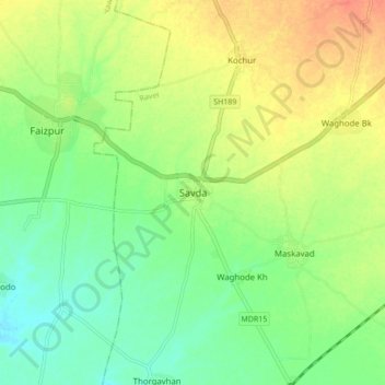
Name: Savda topographic map, elevation, terrain.
Location: Savda, Raver, Jalgaon District, Maharashtra, 425304, India (21.11081 75.84852 21.19081 75.92852)
Average elevation: 735 ft
Minimum elevation: 673 ft
Maximum elevation: 810 ft
Make a donation
Gear up for your next adventure:
As an Amazon Associate, this site earns from qualifying purchases at no extra cost to you.