
Baton Rouge topographic map
Click on the map to display elevation.
About this map
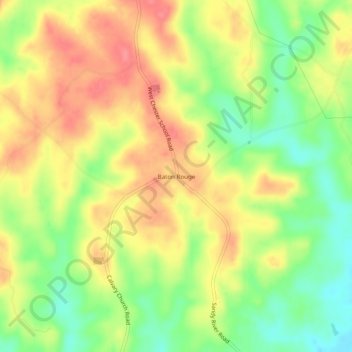
Name: Baton Rouge topographic map, elevation, terrain.
Location: Baton Rouge, Chester County, South Carolina, United States (34.67708 -81.36398 34.71708 -81.32398)
Average elevation: 518 ft
Minimum elevation: 387 ft
Maximum elevation: 630 ft
Chester County trails, hiking, mountain biking, running and outdoor activities
Other topographic maps
Click on a map to view its topography, its elevation and its terrain.
South Carolina Noname 12005 D-0209 Dam
United States > South Carolina > Chester County > Mountain Lakes
Average elevation: 489 ft