
Make a donation
Gear up for your next adventure:
As an Amazon Associate, this site earns from qualifying purchases at no extra cost to you.
Dallas topographic map
Click on the map to display elevation.
Make a donation
Gear up for your next adventure:
As an Amazon Associate, this site earns from qualifying purchases at no extra cost to you.
Dallas
Dallas is along Rickreall Creek, about 15 miles (24 km) west of Salem, at an elevation of 325 feet (99 m) above sea level. It is part of the Salem Metropolitan Statistical Area.
Make a donation
Gear up for your next adventure:
As an Amazon Associate, this site earns from qualifying purchases at no extra cost to you.
About this map
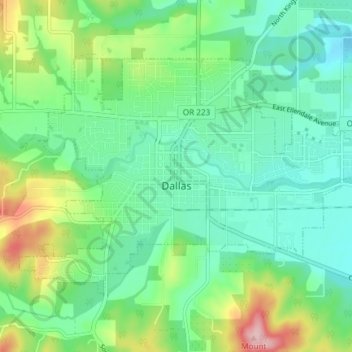
Name: Dallas topographic map, elevation, terrain.
Location: Dallas, Polk County, Oregon, 97338, United States (44.90285 -123.34905 44.93795 -123.27489)
Average elevation: 390 ft
Minimum elevation: 220 ft
Maximum elevation: 823 ft
Polk County trails, hiking, mountain biking, running and outdoor activities
Make a donation
Gear up for your next adventure:
As an Amazon Associate, this site earns from qualifying purchases at no extra cost to you.
Other topographic maps
Click on a map to view its topography, its elevation and its terrain.