Geolocate

Huger topographic map

Click on the map to display elevation.

About this map

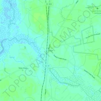
Name: Huger topographic map, elevation, terrain.

Location: Huger, Berkeley County, South Carolina, United States (33.07656 -79.82341 33.11656 -79.78341)

Average elevation: 13 ft

Minimum elevation: -3 ft

Maximum elevation: 26 ft

Berkeley County trails, hiking, mountain biking, running and outdoor activities

Other topographic maps

Click on a map to view its topography, its elevation and its terrain.

Ladson

United States > South Carolina > Berkeley County

Average elevation: 46 ft

Hanahan

United States > South Carolina > Berkeley County

Average elevation: 23 ft

Ladson

United States > South Carolina > Berkeley County

Average elevation: 46 ft

Bonneau

United States > South Carolina > Berkeley County

Average elevation: 59 ft

Hanahan

United States > South Carolina > Berkeley County

Average elevation: 23 ft

Bonneau

United States > South Carolina > Berkeley County

Average elevation: 59 ft

Gear up for your next adventure:

🛡️Bear Spray Outdoor - Protection in bear country hikes
🪶Survival Guide Book - Expert advice for emergency preparedness
🛠️Backpacking Tool Kit - Essential toolkit for outdoor repairs
🧤Tactile Hiking Gloves - Keep hands warm while operating GPS and smartphone screens
🏫Relief Map Kits - Hands-on tools for teaching landforms and elevation

As an Amazon Associate, this site earns from qualifying purchases at no extra cost to you.