Geolocate

San Francisco Bay Area topographic map

Click on the map to display elevation.

San Francisco Bay Area

The San Francisco Bay Area is characterized by a diverse and dynamic topography shaped by geological processes over millions of years. This region features a combination of coastal plains, steep hills, and rugged mountains, all influenced by the tectonic activity associated with the nearby San Andreas Fault and other fault systems. The Pacific Coast Range, which includes the Santa Cruz Mountains and the Marin Hills, runs parallel to the coastline, contributing to the area's vertical relief. The highest peaks, such as Mount Diablo and Mission Peak, rise sharply, creating dramatic vistas. The bay itself is bordered by a variety of landforms, including marshes, alluvial plains, and cliff-lined shores, reflecting both the natural erosion processes and the impacts of urbanization.

About this map

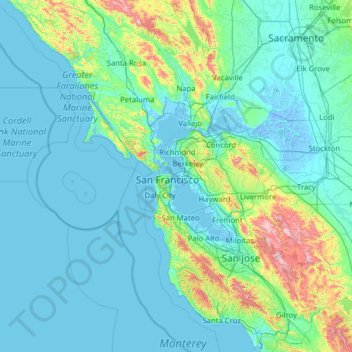
Name: San Francisco Bay Area topographic map, elevation, terrain.

Location: San Francisco Bay Area, San Francisco, California, 94110, United States (36.78850 -123.35585 38.78850 -121.35585)

Average elevation: 371 ft

Minimum elevation: -23 ft

Maximum elevation: 4,252 ft

California trails, hiking, mountain biking, running and outdoor activities

Other topographic maps

Click on a map to view its topography, its elevation and its terrain.

Golden Gate Park

United States > California > San Francisco

In the 1860s, San Franciscans began to feel the need for a spacious public park similar to Central Park, which was then taking shape in New York City. Golden Gate Park was carved out of unpromising sand and shore dunes that were known as the Outside Lands, in an unincorporated area west of San Francisco's…

Average elevation: 233 ft

Golden Gate Park

United States > California > San Francisco

Conceived ostensibly for recreation, the underlying purpose of the park was housing development and the westward expansion of the city. Field engineer William Hammond Hall prepared a survey and topographic map of the park site in 1870 and became its commissioner in 1871. He was later named California's first…

Average elevation: 233 ft

Fort Funston

United States > California > San Francisco

Average elevation: 36 ft

Chimpanzee

United States > California > San Francisco

Average elevation: 46 ft

South Park

United States > California > San Francisco

Average elevation: 33 ft

Seal Rocks

United States > California > San Francisco

Average elevation: 46 ft

Yosemite Creek

United States > California > San Francisco

Average elevation: 118 ft

Precita Park

United States > California > San Francisco

Average elevation: 115 ft

Ocean Beach

United States > California > San Francisco

Average elevation: 69 ft

Gear up for your next adventure:

☀️Outdoor Sunscreen - High protection sunscreen for outdoor activities
🛰️Handheld GPS Units - Professional satellite navigators for precise backcountry mapping
🔥Fast-Boil Camping Stoves - Efficient cooking systems for quick trail meals
🗺️Topographic Maps - Detailed topo maps for hiking, exploring and outdoor navigation
🔦Powerful Headlamps - Ultra-bright hands-free lighting for night navigation

As an Amazon Associate, this site earns from qualifying purchases at no extra cost to you.