Geolocate

Sabrang topographic map

Click on the map to display elevation.

About this map

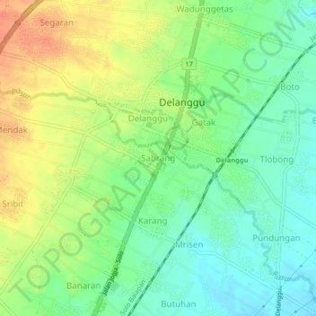
Name: Sabrang topographic map, elevation, terrain.

Location: Sabrang, Klaten, Central Java, Java, 57471, Indonesia (-7.64314 110.67717 -7.60314 110.71717)

Average elevation: 453 ft

Minimum elevation: 387 ft

Maximum elevation: 535 ft

Other topographic maps

Click on a map to view its topography, its elevation and its terrain.

Sanggrahan

Indonesia > Central Java > Klaten

Average elevation: 492 ft

Sungai

Indonesia > Central Java > Klaten > Nanggulan

Average elevation: 371 ft

Gear up for your next adventure:

🎒Hydration Pack - Hands‑free water reservoir for long hikes
🦟Ultrasonic Repellers - Create a bug-free zone at your camp or rest stop
🧭GPS Watch Accessories - Bands and chargers for GPS watches
📦Gear Storage Bags - Organize and protect outdoor equipment
🧭Compass with Lanyard - Easy‑carry compass for navigation

As an Amazon Associate, this site earns from qualifying purchases at no extra cost to you.