Geolocate

Khambhat topographic map

Click on the map to display elevation.

Khambhat

Khambhat is at 22°18′N 72°37′E / 22.3°N 72.62°E / 22.3; 72.62. It has an average elevation of 8 metres (26 ft).

Wikipedia (CC-BY-SA 3.0)

About this map

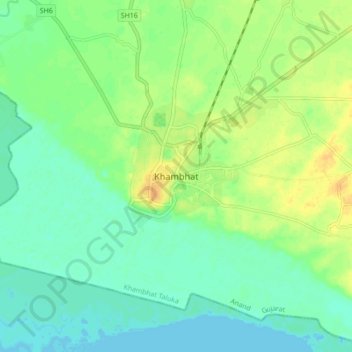
Name: Khambhat topographic map, elevation, terrain.

Location: Khambhat, Khambhat Taluka, Anand, Gujarat, 388600, India (22.27668 72.58431 22.35668 72.66431)

Average elevation: 36 ft

Minimum elevation: 0 ft

Maximum elevation: 92 ft

Other topographic maps

Click on a map to view its topography, its elevation and its terrain.

Madla Lake

India > Gujarat > Khambhat Taluka > Khambhat

Average elevation: 49 ft

Gear up for your next adventure:

🥾Hiking Shoes - Durable and comfortable shoes for trail hiking
🔥Camping Stove - Portable stove for camping and backcountry cooking
Camping Coffee Makers - Enjoy premium coffee at the summit or campsite
📶Vehicle Signal Boosters - Improve reception in rural areas while driving to trailheads
🧭Hiking Compass - Precision compass for reliable navigation in the wilderness

As an Amazon Associate, this site earns from qualifying purchases at no extra cost to you.