
Les Fagnes topographic map
Interactive map
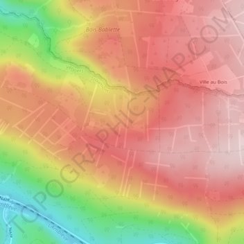
Click on the map to display elevation.
About this map
Name: Les Fagnes topographic map, elevation, terrain.
Location: Les Fagnes, Stoumont, Liège, Wallonie, 4987, Belgique (50.42160 5.75720 50.44160 5.77720)
Average elevation: 1,283 ft
Minimum elevation: 584 ft
Maximum elevation: 1,680 ft
Other topographic maps
Click on a map to view its topography, its elevation and its terrain.
Heilrimont
Belgique > Wallonie > Stoumont > Heilrimont
Heilrimont, Stoumont, Liège, Wallonie, 4987, Belgique
Average elevation: 1,263 ft