Geolocate

Kwale topographic map

Click on the map to display elevation.

About this map

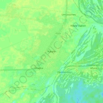
Name: Kwale topographic map, elevation, terrain.

Location: Kwale, Ndokwa West, Delta State, Nigeria (5.65658 6.38655 5.73658 6.46655)

Average elevation: 52 ft

Minimum elevation: 30 ft

Maximum elevation: 66 ft

Gear up for your next adventure:

🚁Photography Drones - Capture stunning aerial views of landforms and topography
📦Gear Storage Bags - Organize and protect outdoor equipment
💧Water Filtration Bottles - Safely drink from streams and lakes while exploring
👟Trail Running Shoes - Lightweight shoes for trail runners
🌲Outdoor Survival Books - Best books on survival skills

As an Amazon Associate, this site earns from qualifying purchases at no extra cost to you.