
Independence Rock topographic map
Interactive map
Click on the map to display elevation.
About this map
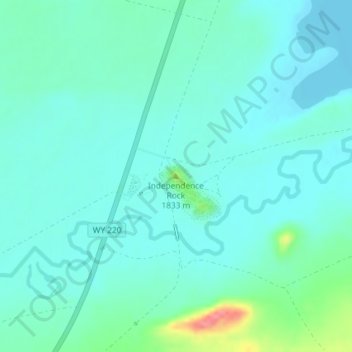
Name: Independence Rock topographic map, elevation, terrain.
Average elevation: 5,912 ft
Minimum elevation: 5,860 ft
Maximum elevation: 6,138 ft
Other topographic maps
Click on a map to view its topography, its elevation and its terrain.
Pinedale
United States of America > Wyoming > Pinedale
Pinedale, Sublette County, Wyoming, United States of America
Average elevation: 7,215 ft
Burgess Junction
United States of America > Wyoming > Burgess Junction
Burgess Junction, Sheridan County, Wyoming, United States of America
Average elevation: 8,068 ft
Etna
United States of America > Wyoming
Etna, Lincoln County, Wyoming, United States of America
Average elevation: 5,791 ft
Red Butte
United States of America > Wyoming > Red Butte
Red Butte, Natrona County, Wyoming, 82604, United States of America
Average elevation: 5,269 ft
Wilson
United States of America > Wyoming > Wilson
Wilson, Teton County, Wyoming, United States of America
Average elevation: 6,407 ft
Bison Peak
United States of America > Wyoming
Bison Peak, Park County, Wyoming, United States of America
Average elevation: 8,028 ft
Seminoe Dam
United States of America > Wyoming
Seminoe Dam, Carbon County, Wyoming, United States of America
Average elevation: 6,781 ft
Collins Place
United States of America > Wyoming > Collins Place
Collins Place, Fremont County, Wyoming, United States of America
Average elevation: 7,041 ft