
Make a donation
Gear up for your next adventure:
As an Amazon Associate, this site earns from qualifying purchases at no extra cost to you.
Forest Park topographic map
Click on the map to display elevation.
Make a donation
Gear up for your next adventure:
As an Amazon Associate, this site earns from qualifying purchases at no extra cost to you.
Forest Park
Solidified lava from Grande Ronde members of the Columbia River Basalt Group underlie Forest Park. About 16 million years ago during the Middle Miocene, the Columbia River ran through a lowland south of its modern channel. Eruptions from linear vents in eastern Oregon and Washington flowed down this channel through what later became the Willamette Valley. These flows, some of which reached the Pacific Ocean, recurred at intervals between 16.5 and 15.6 million years ago and covered almost 60,000 square miles (160,000 km2). About eight separate Grande Ronde Basalt flows have been mapped in the Tualatin Mountains (West Hills), where they underlie the steepest slopes of Forest Park and form the columned rocks visible along Balch Creek Canyon and Northwest Cornell Road. The West Hills were later covered by wind-deposited silts that become unstable when saturated with water. Stream bank instability and siltation are common, and landslides deter urban development at higher elevations.
Make a donation
Gear up for your next adventure:
As an Amazon Associate, this site earns from qualifying purchases at no extra cost to you.
About this map
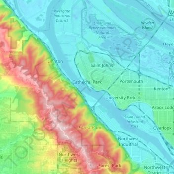
Name: Forest Park topographic map, elevation, terrain.
Average elevation: 299 ft
Minimum elevation: -26 ft
Maximum elevation: 1,260 ft
Multnomah County trails, hiking, mountain biking, running and outdoor activities
Make a donation
Gear up for your next adventure:
As an Amazon Associate, this site earns from qualifying purchases at no extra cost to you.
Other topographic maps
Click on a map to view its topography, its elevation and its terrain.
Powell Butte
United States > Oregon > Multnomah County > Portland
Powell Butte is located in Multnomah County in the U.S. state of Oregon. According to the U.S. National Geodetic Survey, the butte reaches an elevation of 614 feet (187 m), while the Geographic Names Information System lists the mountain's elevation at 627 feet (191 m). J.E. Allen, an emeritus professor of…
Average elevation: 344 ft
Make a donation
Gear up for your next adventure:
As an Amazon Associate, this site earns from qualifying purchases at no extra cost to you.