
Thank you for supporting this site ❤️
Make a donation
Make a donation
Gear up for your next adventure:
As an Amazon Associate, this site earns from qualifying purchases at no extra cost to you.
Pinchollo topographic map
Click on the map to display elevation.
Thank you for supporting this site ❤️
Make a donation
Make a donation
Gear up for your next adventure:
As an Amazon Associate, this site earns from qualifying purchases at no extra cost to you.
About this map
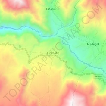
Name: Pinchollo topographic map, elevation, terrain.
Location: Pinchollo, Cabanaconde, Caylloma, Arequipa, Peru (-15.65513 -71.87907 -15.57513 -71.79907)
Average elevation: 12,106 ft
Minimum elevation: 9,409 ft
Maximum elevation: 15,371 ft
Thank you for supporting this site ❤️
Make a donation
Make a donation
Gear up for your next adventure:
As an Amazon Associate, this site earns from qualifying purchases at no extra cost to you.