
Make a donation
Gear up for your next adventure:
As an Amazon Associate, this site earns from qualifying purchases at no extra cost to you.
Town of Wallkill topographic map
Click on the map to display elevation.
Make a donation
Gear up for your next adventure:
As an Amazon Associate, this site earns from qualifying purchases at no extra cost to you.
About this map
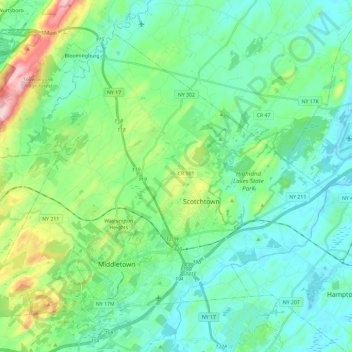
Name: Town of Wallkill topographic map, elevation, terrain.
Location: Town of Wallkill, Orange County, New York, United States (41.42249 -74.51105 41.56576 -74.27681)
Average elevation: 554 ft
Minimum elevation: 338 ft
Maximum elevation: 1,322 ft
Orange County trails, hiking, mountain biking, running and outdoor activities
Make a donation
Gear up for your next adventure:
As an Amazon Associate, this site earns from qualifying purchases at no extra cost to you.
Other topographic maps
Click on a map to view its topography, its elevation and its terrain.
Beaver Dam Lake
United States > New York > Orange County > Town of New Windsor
Average elevation: 387 ft
Make a donation
Gear up for your next adventure:
As an Amazon Associate, this site earns from qualifying purchases at no extra cost to you.
Vails Gate Junction
United States > New York > Orange County > Town of New Windsor > Vails Gate
Average elevation: 302 ft
Make a donation
Gear up for your next adventure:
As an Amazon Associate, this site earns from qualifying purchases at no extra cost to you.
Make a donation
Gear up for your next adventure:
As an Amazon Associate, this site earns from qualifying purchases at no extra cost to you.
Make a donation
Gear up for your next adventure:
As an Amazon Associate, this site earns from qualifying purchases at no extra cost to you.
Cornwall Landing
United States > New York > Orange County > Village of Cornwall-on-Hudson
Average elevation: 243 ft
Make a donation
Gear up for your next adventure:
As an Amazon Associate, this site earns from qualifying purchases at no extra cost to you.
Nathaniel Wetlands Inventory - R5UBH - 0.09 acres
United States > New York > Orange County
Average elevation: 453 ft