
Thank you for supporting this site ❤️
Make a donation
Make a donation
Gear up for your next adventure:
As an Amazon Associate, this site earns from qualifying purchases at no extra cost to you.
Garaitarreta topographic map
Click on the map to display elevation.
Thank you for supporting this site ❤️
Make a donation
Make a donation
Gear up for your next adventure:
As an Amazon Associate, this site earns from qualifying purchases at no extra cost to you.
About this map
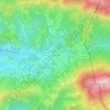
Name: Garaitarreta topographic map, elevation, terrain.
Location: Garaitarreta, Bera, Baztan-Bidasoa, Navarre, Espagne (43.26103 -1.66537 43.30103 -1.62537)
Average elevation: 886 ft
Minimum elevation: 161 ft
Maximum elevation: 2,198 ft
Thank you for supporting this site ❤️
Make a donation
Make a donation
Gear up for your next adventure:
As an Amazon Associate, this site earns from qualifying purchases at no extra cost to you.