
Make a donation
Gear up for your next adventure:
As an Amazon Associate, this site earns from qualifying purchases at no extra cost to you.
Hạ Long topographic map
Click on the map to display elevation.
Make a donation
Gear up for your next adventure:
As an Amazon Associate, this site earns from qualifying purchases at no extra cost to you.
About this map
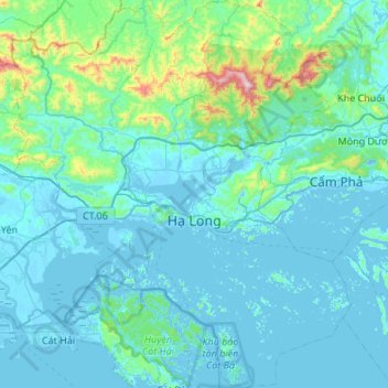
Name: Hạ Long topographic map, elevation, terrain.
Location: Hạ Long, Phường Tuần Châu, Quảng Ninh Province, Vietnam (20.68689 106.82556 21.23899 107.34692)
Average elevation: 292 ft
Minimum elevation: -30 ft
Maximum elevation: 3,379 ft
Make a donation
Gear up for your next adventure:
As an Amazon Associate, this site earns from qualifying purchases at no extra cost to you.
Other topographic maps
Click on a map to view its topography, its elevation and its terrain.
Hạ Long Bay
Vietnam > Quang Ninh Province > Ha Long
Due to a simultaneous combination of ideal factors such as thick, pale, grey, and strong limestone layers, which are formed by fine-grained materials; hot and moist climate and slow tectonic process as a whole; Hạ Long Bay has had a complete karst evolution for 20 million years. There are many types of karst…
Average elevation: 0 ft
Make a donation
Gear up for your next adventure:
As an Amazon Associate, this site earns from qualifying purchases at no extra cost to you.