
Make a donation
Gear up for your next adventure:
As an Amazon Associate, this site earns from qualifying purchases at no extra cost to you.
Halver topographic map
Click on the map to display elevation.
Make a donation
Gear up for your next adventure:
As an Amazon Associate, this site earns from qualifying purchases at no extra cost to you.
Halver
Halver liegt im westlichen märkischen Sauerland an der Grenze zwischen dem Rheinland und Westfalen, etwa 10 Kilometer westlich von Lüdenscheid. Der Hauptort befindet sich auf einer Bergkuppe mit einer Höhenlage von 374 m ü. NN (Bolsenbachtal) bis 420 m ü. NN (südliches Stadtgebiet). Der tiefste Punkt im gesamten Stadtgebiet liegt mit 275 m ü. NN bei Oberbrügge, der höchste mit 433 m ü. NN bei Hagebücherhöh.
Make a donation
Gear up for your next adventure:
As an Amazon Associate, this site earns from qualifying purchases at no extra cost to you.
About this map
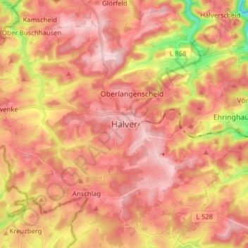
Name: Halver topographic map, elevation, terrain.
Average elevation: 1,230 ft
Minimum elevation: 804 ft
Maximum elevation: 1,450 ft
Make a donation
Gear up for your next adventure:
As an Amazon Associate, this site earns from qualifying purchases at no extra cost to you.