
Make a donation
Gear up for your next adventure:
As an Amazon Associate, this site earns from qualifying purchases at no extra cost to you.
Lydney topographic map
Click on the map to display elevation.
Make a donation
Gear up for your next adventure:
As an Amazon Associate, this site earns from qualifying purchases at no extra cost to you.
About this map
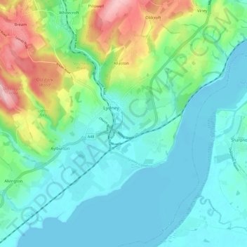
Name: Lydney topographic map, elevation, terrain.
Average elevation: 148 ft
Minimum elevation: -10 ft
Maximum elevation: 610 ft
Make a donation
Gear up for your next adventure:
As an Amazon Associate, this site earns from qualifying purchases at no extra cost to you.
Other topographic maps
Click on a map to view its topography, its elevation and its terrain.
Five Acres
United Kingdom > England > Gloucestershire > Forest of Dean > Berry Hill
Average elevation: 640 ft
Make a donation
Gear up for your next adventure:
As an Amazon Associate, this site earns from qualifying purchases at no extra cost to you.
Broadwell
United Kingdom > England > Gloucestershire > Forest of Dean > Broadwell
Average elevation: 604 ft