
Make a donation
Gear up for your next adventure:
As an Amazon Associate, this site earns from qualifying purchases at no extra cost to you.
Hassi Ben Abdellah topographic map
Click on the map to display elevation.
Make a donation
Gear up for your next adventure:
As an Amazon Associate, this site earns from qualifying purchases at no extra cost to you.
Hassi Ben Abdellah
Hassi Ben Abdellah lies at an elevation of 159 metres (522 ft) above sea level, 20 kilometres (12 mi) from the provincial capital Ouargla, and 8 kilometres (5.0 mi) from the district capital Sidi Khouiled. The land in the area alternates between sand dunes and flat rocky plains dotted with small areas of fertile oases. There is a large palm plantation to the west of Hassi Ben Abdellah that is irrigated with oasis water.
Make a donation
Gear up for your next adventure:
As an Amazon Associate, this site earns from qualifying purchases at no extra cost to you.
About this map
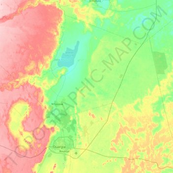
Name: Hassi Ben Abdellah topographic map, elevation, terrain.
Location: Hassi Ben Abdellah, Sidi Khouiled District, Ouargla, Algeria (31.82395 5.43438 32.61491 6.10110)
Average elevation: 459 ft
Minimum elevation: 328 ft
Maximum elevation: 669 ft
Make a donation
Gear up for your next adventure:
As an Amazon Associate, this site earns from qualifying purchases at no extra cost to you.
Other topographic maps
Click on a map to view its topography, its elevation and its terrain.