
Make a donation
Gear up for your next adventure:
As an Amazon Associate, this site earns from qualifying purchases at no extra cost to you.
Gaià topographic map
Click on the map to display elevation.
Make a donation
Gear up for your next adventure:
As an Amazon Associate, this site earns from qualifying purchases at no extra cost to you.
About this map
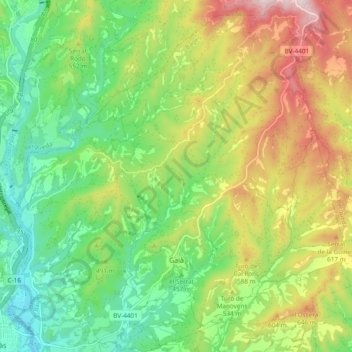
Name: Gaià topographic map, elevation, terrain.
Location: Gaià, Bages, Barcelona, Catalonië, Spanje (41.89850 1.88002 41.96726 1.97525)
Average elevation: 1,614 ft
Minimum elevation: 1,037 ft
Maximum elevation: 2,530 ft
Make a donation
Gear up for your next adventure:
As an Amazon Associate, this site earns from qualifying purchases at no extra cost to you.
Other topographic maps
Click on a map to view its topography, its elevation and its terrain.
Montserrat
Spanje > Catalonië > Bages > Marganell
Het Klooster van Montserrat (Catalaans: Monastir de Montserrat) bevindt zich op een hoogte van 720 meter aan de oostzijde van de berg. Het staat bekend als bedevaarts- en toeristenoord. Ook is er een hotel gevestigd.
Average elevation: 2,110 ft