
Thank you for supporting this site ❤️
Make a donation
Make a donation
Gear up for your next adventure:
As an Amazon Associate, this site earns from qualifying purchases at no extra cost to you.
Dufftown topographic map
Click on the map to display elevation.
Thank you for supporting this site ❤️
Make a donation
Make a donation
Gear up for your next adventure:
As an Amazon Associate, this site earns from qualifying purchases at no extra cost to you.
About this map
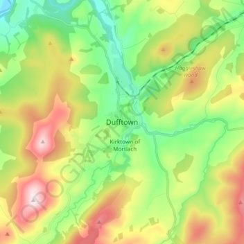
Name: Dufftown topographic map, elevation, terrain.
Location: Dufftown, Moray, Scotland, AB55 4AD, United Kingdom (57.40490 -3.16835 57.48490 -3.08835)
Average elevation: 879 ft
Minimum elevation: 259 ft
Maximum elevation: 1,860 ft
Thank you for supporting this site ❤️
Make a donation
Make a donation
Gear up for your next adventure:
As an Amazon Associate, this site earns from qualifying purchases at no extra cost to you.