
Thank you for supporting this site ❤️
Make a donation
Make a donation
Gear up for your next adventure:
As an Amazon Associate, this site earns from qualifying purchases at no extra cost to you.
Ciscar topographic map
Click on the map to display elevation.
Thank you for supporting this site ❤️
Make a donation
Make a donation
Gear up for your next adventure:
As an Amazon Associate, this site earns from qualifying purchases at no extra cost to you.
About this map
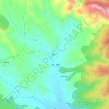
Name: Ciscar topographic map, elevation, terrain.
Location: Ciscar, Benabarre, La Ribagorza, Huesca, Aragón, 22585, España (42.05637 0.52932 42.09637 0.56932)
Average elevation: 2,067 ft
Minimum elevation: 1,749 ft
Maximum elevation: 2,795 ft
Thank you for supporting this site ❤️
Make a donation
Make a donation
Gear up for your next adventure:
As an Amazon Associate, this site earns from qualifying purchases at no extra cost to you.